A recent subdivision earthworks project along the Hutt River's western terrace encountered a buried paleochannel that the initial desktop study completely missed. The fill material was saturated, loose, and varied in depth from 2 to 7 meters across just 150 meters of frontage. Tracking that channel's boundaries mechanically would have meant sinking dozens of test pits through access-restricted paddocks. Instead, we deployed a multi-electrode resistivity line that delineated the low-resistivity infill from the surrounding dense gravels in a single afternoon, giving the earthworks contractor a precise cut-and-fill map before a bucket touched soil. For sites where the Wellington Fault's proximity creates complex juxtapositions of weathered greywacke and recent alluvium, resistivity surveys provide a continuous subsurface profile that point investigations alone cannot resolve. We combine vertical electrical sounding (VES) for depth soundings with 2D tomography when lateral continuity matters, always calibrating results against borehole control. The CPT testing data often serves as that calibration baseline, especially in the Hutt Valley's interbedded silts and sands.
Resistivity contrast between saturated alluvium and dense gravel in the Hutt Valley can exceed 1:100, making VES the fastest tool for mapping buried channel boundaries before excavation.
Methodology applied in Upper Hutt
Critical ground factors in Upper Hutt
The Hutt Valley's winter rainfall—averaging 120 mm in July alone—saturates the near-surface soils and collapses resistivity contrasts that would be diagnostic in drier months. Running a survey the week after heavy rain can mask the boundary between natural silts and seepage zones, leading to misinterpreted stratigraphy. We schedule resistivity campaigns during the drier late-summer window wherever possible, and when winter work is unavoidable, we increase electrode density and cross-reference with test pit logs to correct for moisture skew. A more insidious risk arises from the buried services crisscrossing Upper Hutt's older subdivisions: stray currents from grounded electrical lines or cathodic protection on pipelines can couple into the measurement array and produce artifacts that look deceptively like geological anomalies. Our field protocols include pre-survey utility scanning and time-domain filtering to identify and reject coupled noise before inversion.
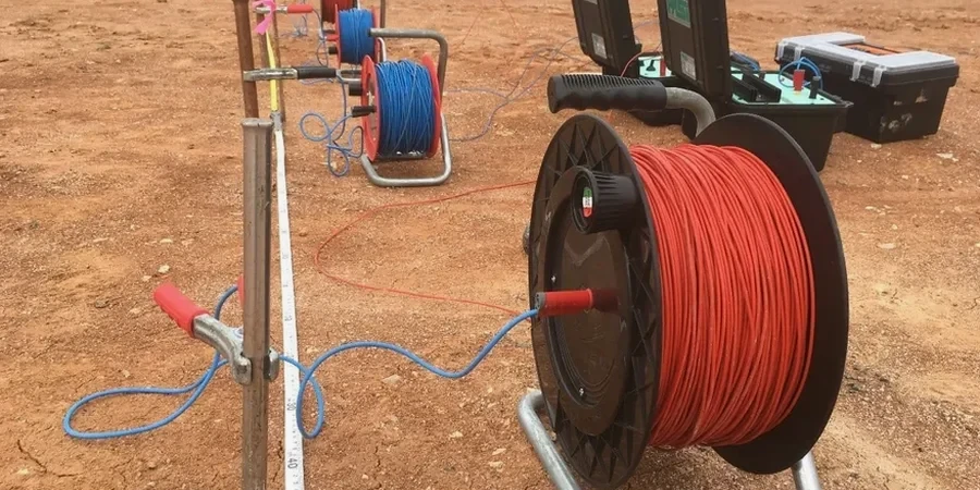
Our services
Our resistivity services in Upper Hutt are integrated into a broader geotechnical investigation workflow. The following methods are frequently deployed alongside VES to provide a complete ground model:
2D Electrical Resistivity Tomography
Continuous resistivity cross-sections for mapping lateral variations in alluvial terrace deposits, paleochannels, and fill boundaries along proposed road or pipeline alignments.
Vertical Electrical Sounding (VES)
Point-depth resistivity soundings for estimating depth to bedrock, groundwater table profiling, and aggregate resource volume estimation in river terrace gravels.
Induced Polarization (IP)
Chargeability measurements run concurrently with resistivity to discriminate clay-rich horizons from water-saturated sands where resistivity alone is ambiguous.
Borehole-to-Surface Calibration
Direct correlation of resistivity profiles with SPT N-values and recovered core lithology to constrain geophysical inversion models and produce defensible interpretations.
Frequently asked questions
How much does an electrical resistivity / VES survey cost in Upper Hutt?
For a single VES sounding or a short 2D resistivity line suitable for a residential or light commercial site in the Hutt Valley, budgets typically range from NZ$930 to NZ$1,520. The final figure depends on line length, electrode spacing, terrain access, and whether IP chargeability is collected simultaneously. Larger subdivision-scale surveys with multiple parallel lines and deeper investigation targets are quoted on a project basis after reviewing site plans.
What depth can a VES survey reach in the Hutt Valley's geology?
With a Schlumberger array using a 200-meter current-electrode spread, we routinely achieve investigation depths of 30 to 50 meters in Upper Hutt's alluvial and terrace deposits. The actual penetration is controlled by the resistivity of the near-surface layers: conductive clays attenuate signal faster than dry gravels, so depth of investigation is site-specific and confirmed during data inversion.
How long does a resistivity survey take on site?
A single VES sounding takes approximately 45 to 60 minutes to set up and measure. A 2D tomography line of 100 meters with 2-meter electrode spacing typically requires 2 to 3 hours of field time. Terrain, vegetation, and the need to avoid buried services can extend these durations, and we discuss timing during the site walkover.
Can resistivity surveys distinguish between clay and water-saturated silt?
The reference range for this service in Upper Hutt is NZ$930 - NZ$1.520. The final price depends on the project scope and volume.
Do I still need boreholes or test pits if a resistivity survey is done?
Yes—geophysical methods provide continuous spatial coverage but require calibration. We recommend at least one borehole or test pit intersecting key resistivity units to tie the geophysical signature to actual soil or rock type, groundwater level, and geotechnical properties. The investigation is strongest when geophysics and intrusive sampling work together.