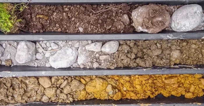
A 5-tonne excavator with a 600 mm cleanout bucket arrives on site in Upper Hutt. Within the first metre of digging, you see the transition from silty topsoil into the dense river gravels that define the Hutt Valley floor. An exploratory test pit is the most direct method we have for observing soil structure, moisture conditions, and fill boundaries before foundations are designed. Upper Hutt sits on the active floodplain of the Hutt River, where alluvial deposits can shift from sandy silt to coarse gravel within a few metres laterally. We log each pit wall by hand, photograph the strata at a vertical scale, and collect bulk samples for laboratory classification. The technique works well on flat residential sections in Trentham, sloping sites in Maoribank, and commercial lots near Fergusson Drive where undocumented historical fill is common. For deeper refusal depths or cemented layers, we often combine test pits with SPT drilling to extend the profile below the water table or beyond excavator reach.
A test pit wall reveals more about ground variability than a dozen borehole logs can capture in alluvial terrain.
Methodology applied in Upper Hutt
Critical ground factors in Upper Hutt
Upper Hutt sits at an elevation of roughly 50-60 m above sea level on the Hutt River floodplain, with the Wellington Fault trace running just west of the city boundary. A shallow groundwater table combined with unconsolidated alluvial gravels creates liquefaction susceptibility across much of the valley floor—MBIE guidance maps classify large residential zones as potentially vulnerable. Skipping an exploratory test pit in these conditions means the designer never sees the actual stratigraphy: buried organic layers, uncompacted historical fill, or loose sand lenses that can settle differentially under seismic shaking. We have observed pits where the water table appeared at only 80 cm depth in winter, saturating the base and requiring immediate stabilisation. If the pit walls collapse before logging is complete, the information is lost. Our technical team follows NZGS best practice for shallow excavations, benching or battering the walls when depth exceeds 1.5 m, and never enters an unsupported pit deeper than that without a spotter and documented risk assessment.
Our services
Our Upper Hutt field teams mobilise quickly for exploratory test pit work, combining the pit data with complementary geotechnical services across the Hutt Valley.
Test Pit Logging & Sampling
Excavator-procured pits logged to NZGS standards with photo documentation, bulk sampling, and in-situ strength testing. We handle traffic management on residential streets and coordinate with utility locators before digging.
Combined Shallow & Deep Investigation
Pair exploratory test pits with cone penetration testing or SPT drilling where refusal depths exceed 3 m. The pit provides visual ground truth; the deep tools extend the profile to bearing stratum.
Frequently asked questions
How much does an exploratory test pit cost for a residential site in Upper Hutt?
For a standard residential investigation in Upper Hutt with two to three test pits, the cost typically falls between NZ$800 and NZ$1,390. The final price depends on the number of pits, access conditions for the excavator, and whether in-situ density testing or laboratory classification is required on the recovered samples.
What depth can you reach with an exploratory test pit in the Hutt Valley?
Most test pits in the Hutt Valley reach between 1.5 and 3.5 metres depth with a standard 5-tonne excavator. Depth is limited by the machine's reach, groundwater inflow, and the stability of the pit walls in the local alluvial gravels. Below the water table or beyond 3.5 m, we switch to SPT drilling or CPT probing to extend the investigation.
Do you need a building consent to open exploratory test pits in Upper Hutt?
Exploratory test pits dug for geotechnical investigation purposes do not require a building consent under the Building Act. However, you must locate underground services before digging, and if the pit is deeper than 1.5 m, the excavation must comply with WorkSafe New Zealand requirements for shoring, battering, or benching to prevent collapse.
How long does a test pit investigation take on site?
A typical residential investigation with two to three exploratory test pits takes half a day on site. The excavator opens each pit in 20-30 minutes, we log, photograph, and sample for another 30 minutes per pit, and backfilling with compaction adds an additional 15-20 minutes. We aim to have the site restored and the equipment off-site by early afternoon.